Soil Moisture Active Passive (SMAP)
SMAP is one of four Tier 1 missions recommended by the National Research Council's Committee on Earth Science and Applications from Space. The science goal is to combine the attributes of the radar (high spatial resolution) and radiometer (high soil moisture accuracy) observations to provide estimates of soil moisture in the top 5 cm of soil with an accuracy of 0.04 v/v at 10 km resolution, and freeze-thaw state at a spatial resolution of 1-3 km. The payload consists of an L-band radar (1.26 GHz; HH, VV, HV) and an L-band radiometer (1.41 GHz; H, V, U) sharing a single feed horn and parabolic mesh reflector. The reflector is offset from nadir, and rotates about the nadir axis at 14.6rpm, providing a conically-scanning antenna beam with a constant surface incidence angle of approximately 40°. SMAP has been launched on 31st January 2015 into a 680 km near-polar, sun-synchronous orbit with an 8-day exact repeat cycle and 6am/6pm Equator crossing time. The scan configuration yields a 1000 km swath, with a 40 km radiometer resolution and 1-3 km synthetic aperture radar resolution (over the outer 70% of the swath) that provides global coverage within 3 days at the Equator and 2 days at boreal latitudes.
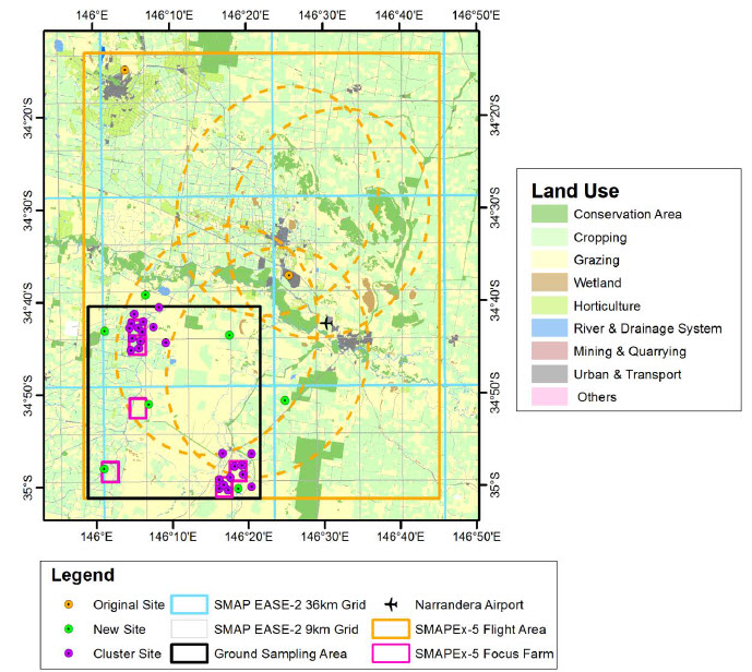
Totally eight flights were designed over a flight area covering at least one SMAP radiometer footprint (see the figure below). Each of flights was planned in coincidence with the coverage of SMAP radiometer for SMAP validation.
Overview of the SMAPEx-5 experiment. The map shows the area covered by airborne mapping (orange
rectangle for SMAP 3dB footprints), the ground soil moisture networks, and SMAP grids for radiometer (36 km) and
active-passive (9 km) products.The features of SMAP are summarized below.
Mission
SMAP
Sensors
L-band radar (active) and L-band radiometer (passive) share a single feedhorn and reflector.
Spacecraft
SMAP
Launch date
1st, Jan., 2015
Orbit
Circular polar orbit, 8-day repeating ground track.
Radar frequency (GHz)
1.26 (L-band); non-imaging synthetic aperture
Radar real-aperture footprint (km)
29*35
Radar polarisation
HH, VV, HV, VH
Incidence angle(°)
40